The Access Across America series measures accessibility to jobs via various modes of transportation in major metropolitan areas across the United States. As of 2015, work is funded under the National Accessibility Evaluation pooled-fund study.
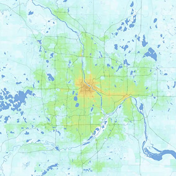
Accessibility is the ease of reaching valued destinations. It can be measured for various transportation modes, to different types of destinations, and at different times of day. There are a variety of ways to define accessibility, but the number of destinations reachable within a given travel time is the most comprehensible and transparent, as well as the most directly comparable across cities.
The Access in Appalachia Pilot Implementation Project explored transportation accessibility within the Appalachian Region, focusing on the ease with which residents can reach essential destinations. Commissioned by the Appalachian Regional Commission (ARC) and led by the Maryland Department of Transportation State Highway Administration, this project advanced our understanding of economic development, land use, and transportation infrastructure. It included multimodal access to jobs, health care, education, entertainment, and intermodal freight facilities.
Key findings highlight significant urban-rural divides in accessibility, the impact of land-use planning on economic hubs, and the presence of health care deserts in rural areas. The project aligned with regional state DOTs' missions to enhance mobility and access and aimed to inform statewide decision-making processes.
The Observatory can provide cutting-edge accessibility evaluation tailored to meet your needs. Services range from a complete project to a component of a larger effort and may include:
Custom Accessibility Evaluation Deliverables can include detailed accessibility datasets, customized summary datasets, and reports describing methodology and results. Accessibility evaluations can be based on existing network and land-use datasets, data collected by the Observatory, or custom-developed data (described below).
Develop Scenario Network Datasets Drawing from existing plans or scenario descriptions, the Observatory can create transit and/or road network datasets suitable for use in accessibility evaluation projects. This allows meaningful comparisons between a baseline/no-build scenario and multiple investment or service scenarios.
Develop Scenario Land-Use Datasets The Observatory can process existing land-use scenario or forecast data for compatibility and use in accessibility evaluation or construct new land-use scenarios from baseline data.
Custom Accessibility Summaries and Reports Customized analysis of existing data published by the Accessibility Observatory can provide new insights without the need for new accessibility calculations. Examples include regional transportation equity analysis, location suitability analysis, and custom mapping and visualization. The Observatory will help identify existing accessibility datasets that can meet your needs.
Massachusetts Jobs Access Data Dashboard Massachusetts DOT created a dashboard that displays job accessibility data across the state for use in project scoring.
Trips DC The District DOT built a trip estimation generator for mixed-use developments within Washington, D.C.
Rethinking I-94 MnDOT is using accessibility data to evaluate accessibility as part of its community engagement project.